INSIVUMEH Alerta de Terremotos: Guatemala's Official Earthquake Warning System
by INSIVUMEH
0IOSEducation
Official earthquake alert application from Guatemala's National Seismological Institute. Provides localized early warnings for seismic events within 50-150km range, targeting residents and visitors in seismically active regions.
Detailed Review
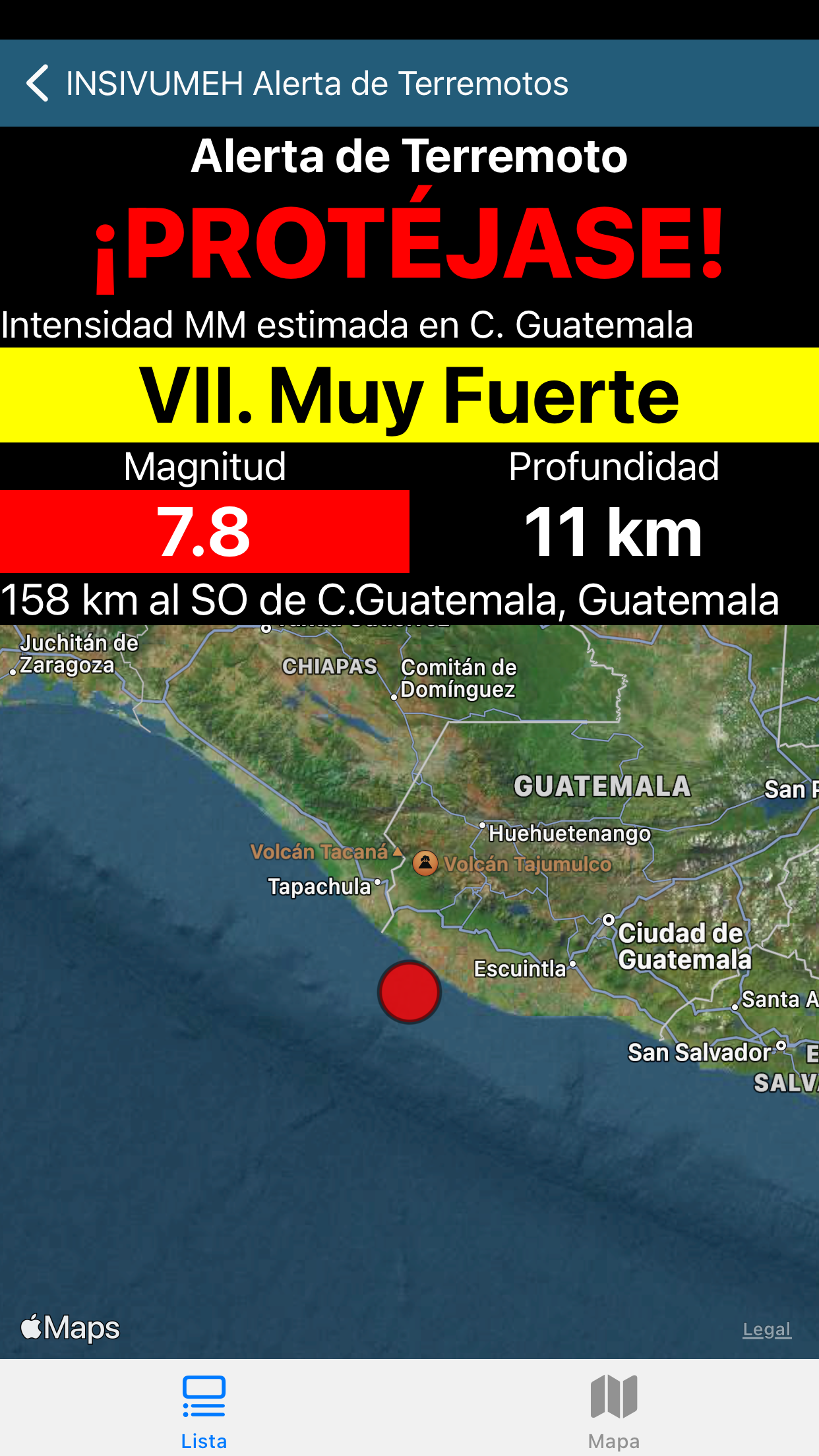
INSIVUMEH Alerta de Terremotos represents Guatemala's official mobile earthquake warning system, developed by the National Institute of Seismology, Volcanology, Meteorology and Hydrology. The application serves as a critical public safety tool in a region prone to significant seismic activity, delivering real-time notifications from the national monitoring network directly to users' mobile devices.
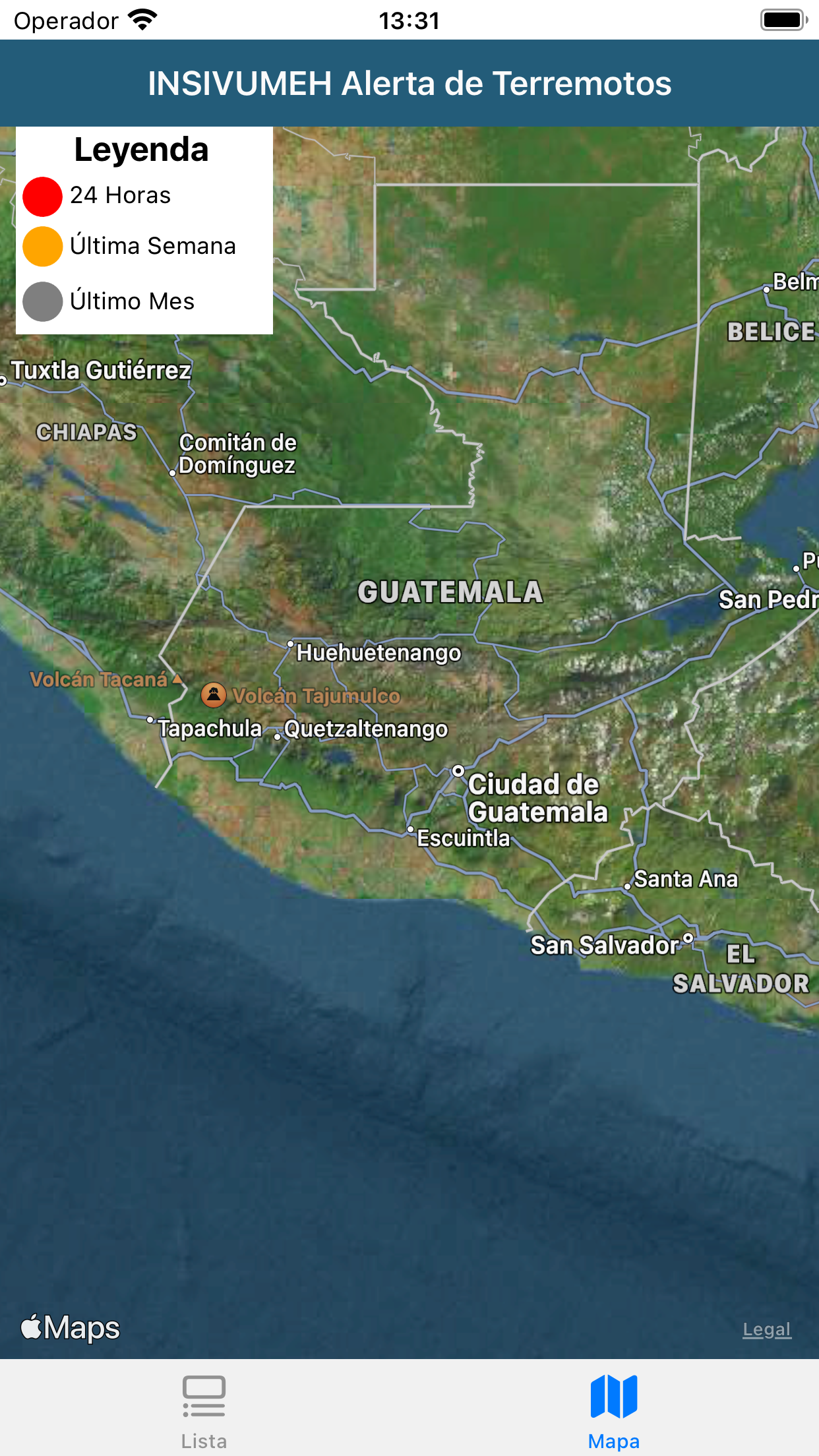
The core functionality centers on receiving data from INSIVUMEH's National Data Center and calculating whether seismic events could be felt at the user's location or designated points of interest. The system operates within a specific 50-150 kilometer effective range, as seismic waves traveling shorter distances provide insufficient warning time, while events beyond 150 kilometers typically don't cause significant damage despite being potentially noticeable. The application processes seismic data to provide, in optimal conditions, early warnings that allow users precious seconds to take protective actions.
User experience revolves around the notification system, which must balance urgency with clarity. The interface appears designed for immediate comprehension during high-stress situations, with visual and auditory alerts that convey critical information quickly. Real-world usage patterns suggest the application operates primarily in the background, activating only when seismic activity meets predetermined thresholds for user notification. The location-based functionality requires persistent GPS access to accurately assess potential impact zones relative to epicenter distances.
No user reviews are currently available for analysis, as the application appears to be newly launched or has limited public adoption thus far. This absence of user feedback makes comprehensive assessment challenging, though it typically indicates either recent deployment or specialized target audience usage rather than broader public adoption patterns.
The application's primary strength lies in its official data source and scientifically calibrated alert thresholds, though its effectiveness remains geographically constrained to specific distance parameters. Limitations include the narrow operational range and dependency on network connectivity for real-time data transmission. Ideal use cases involve urban populations within Guatemala's seismic zones seeking official, rather than crowd-sourced, earthquake notifications with validated scientific backing.
Key Features
- •Official seismic data integration from Guatemala's national monitoring network ensuring reliable, scientifically validated earthquake information
- •Distance-based alert system that calculates potential impact within 50-150km range for appropriate warning timing
- •Location-aware notifications that assess whether seismic events could be felt at user's precise GPS coordinates
- •Early warning capability providing seconds to minutes of advance notice depending on epicenter distance
- •Multiple points of interest monitoring allowing users to track seismic activity affecting specific locations beyond their immediate position
Why Users Love It
Official government seismic data
Scientifically calibrated alert thresholds
Perfect for: Guatemala residents and visitors in seismic zones
Screenshots