by California Department of Transportation
Detailed Review
Key Features
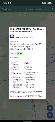
- •Live Traffic Cameras: Access hundreds of video feeds from across the state's highway system, allowing visual verification of traffic, weather, and road conditions.
- •Real-Time Incident Reports: View official Caltrans and CHP alerts for collisions, hazards, and roadwork directly plotted on an interactive map.
- •Chain Control & Winter Driving Info: Get critical updates on mandatory chain requirements and highway closures in mountain passes during winter storms.
- •Customizable Alert Filters: Set filters to display only specific event types, such as construction, lane closures, or traffic breaks, reducing map clutter.
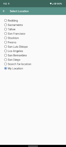
- •Personalized Route Planning: Save frequent routes to quickly check for any alerts or delays along a specific corridor before departing.
- •Traffic Speed Layers: See color-coded traffic flow data on major highways to identify congestion hotspots and estimate travel times.
Why Users Love It
Perfect for: Perfect for California-based drivers, truckers, and travelers who need authoritative, real-time information on highway conditions, closures, and winter weather impacts.
Screenshots


Ranking History
Track QuickMap's performance in Maps & Navigation over the last 30 days
Current Rank
#41
Best Rank
#41
All-time high
Average Rank
#41
30-day average
User Reviews
Love it. I'm a daily freeway driver and NEVER go a day without this app. I practically live on it 24/7. Options to pick specific traffic info you want to see is great. Very informative and accurate. The only thing I suggest is to have a dark mode option. The constant bright white is straining on the eyes at night (even with lowering screen brightness on the phone) I get migraines VERY easily so a dark theme would really help at night.
BEST Traffic App ever. Accurate to the minute. Click on a Triangle and you get the actual entries made by CHP Dispatch. WAY better than listening to local radio.
This is a great app. One request - could you add the four links used on the Quick Map website to the app options or help section so we can go directly to this info as needed (especially planned lane closures). Thanks.
It's free. It works as said. It's very informative and no ads. Awesome app for knowing what's out there before you get there. I tell others about it so they can use it
Just played with this for a minute. Better integrated with cameras and such than previously. Rest stop info, says Waze integration which I can't verify.
App Details
Developer
California Department of Transportation
Platform
androidRating
Last Updated
12/25/2025