
by onXmaps
Detailed Review
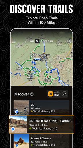
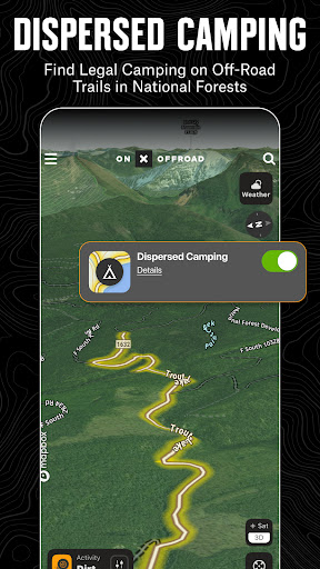
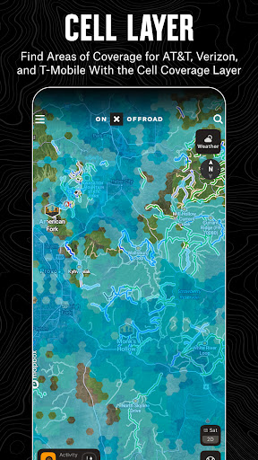
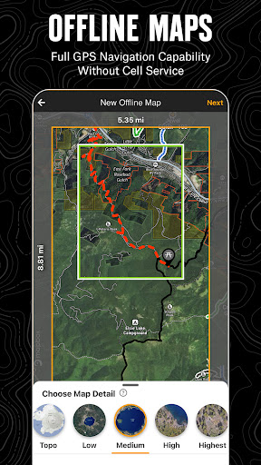
Key Features
- •Offline map downloading enables navigation in remote areas without cellular service, crucial for backcountry safety and continuous routing
- •Vehicle-specific trail filtering allows users to find routes appropriate for their 4x4, ATV, or moto equipment, preventing unsuitable trail attempts
- •Motorized Dispersed Camping Layer identifies legal off-grid camping areas in National Forests, addressing a key pain point for overlanding enthusiasts
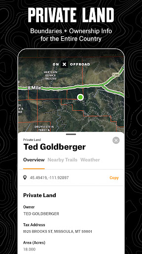
- •Land ownership boundary mapping shows public/private divisions with verified data, helping users avoid trespassing on restricted properties
- •Multi-platform synchronization enables route planning on desktop computers with seamless transfer to mobile devices for field execution
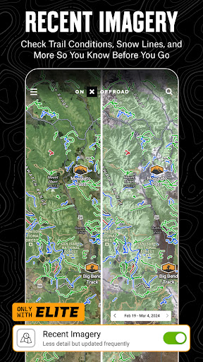
- •3D topographic mapping provides enhanced terrain visualization for assessing trail difficulty and planning appropriate routes
Why Users Love It
Perfect for: Off-road enthusiasts exploring remote terrain with mixed land ownership
Screenshots
Ranking History
Track onX Offroad: Trail Maps & GPS's performance in Maps & Navigation over the last 30 days
Current Rank
#28
13 from last week
Best Rank
#13
All-time high
Average Rank
#20
30-day average
Questions & Answers
Which Android app is best for navigating off-road trails while avoiding private property?
onX Offroad is a navigation tool designed for outdoor recreation in remote areas. Its core utility lies in its detailed, map-based display of land own...
Ad — Extra Q&As are paid placements. Editorial standards apply; rankings unchanged.Learn more
What's the best Android app for finding off-road trails, planning 4x4 routes, and navigating in remote areas without cell service using offline maps and GPS?
onX Offroad: Trail Maps & GPS is an excellent Android app for finding off-road trails and planning 4x4 routes, especially in areas with limited or no ...
What's the best Android app for finding off-road trails and planning off-road adventures?
onX Offroad is an excellent app for anyone passionate about off-roading. It provides detailed, up-to-date trail maps specifically designed for off-roa...
User Reviews
I can't go without this app anymore! In Southwest Idaho, the Owyhee Mountains and surrounding high mountain deserts there's a lot of private land, mostly cattle ranchers that need to lock their gates. There's also a lot nice trails, beautiful country, historical sites, fishing and rockhounding areas on public land. Without onX you can try to get to a specific place and never find a route through. Knowing where you need to route around before you go is what makes all the difference!
I have used this excessively in the Rocky Mountain States and I absolutely love it. Having said that, I really despise their billing and the inaccessibility of a non-renewable button or checkbox or some way to indicate that I don't want it to renew. I am unable to find that in either the app or on the web browser so I ended up canceling my account which loses all data and sucks. 1 star for just not having a simple toggle switch that allows the user to easily not renew.
I can't imagine not having the app when dirt biking through the woods! For way off-grid I use the offline map feature using an older, non wireless connected phone with the app on a tank holder. It works great! One small issue, property owner font is extremely hard to read. The size is fine, the outline style font is bad. Please update to solid font. Great product!
I can't imagine not having the app when dirt biking through the woods! For way off-grid I use the offline map feature using an older, non wireless connected phone with the app on a tank holder. It works great! One small issue, property owner font is extremely hard to read. The size is fine, the outline style font is bad. Please update to solid font. Great product!
I really enjoy this app! Using this app for about 6 months, I have been much more able to find new places to fly that are steep enough to launch and safe enough to land with my speed wings. A wing's glide rate, or elevation change over distance is easy to calculate over the terrain with this apps features so that I bring the right wing to have the most fun possible... safely. It is also a bonus to see where my Verizon cell phone gets service in case emergency help is needed 👍
App Details
Developer
onXmaps
Platform
androidRating
Last Updated
1/8/2026