INSIVUMEH Alerta de Terremotos: Comprehensive Earthquake Alert System Analysis
by GEO INSIVUMEH
INSIVUMEH Alerta de Terremotos provides automated earthquake notifications and potential early warnings for Guatemala. The free app delivers real-time seismic alerts through multiple instrument networks, though technical limitations may affect reliability.
Detailed Review
INSIVUMEH Alerta de Terremotos represents a specialized seismic monitoring application developed by Guatemala's National Institute for Seismology, Volcanology, Meteorology and Hydrology. This government-developed application occupies a unique position in the disaster preparedness market, specifically tailored for Guatemalan seismic activity while operating as a complementary service to the institute's official monitoring efforts. The application functions as both an information dissemination tool and potential early warning system, though developers explicitly note its susceptibility to technical failures due to its automated nature.
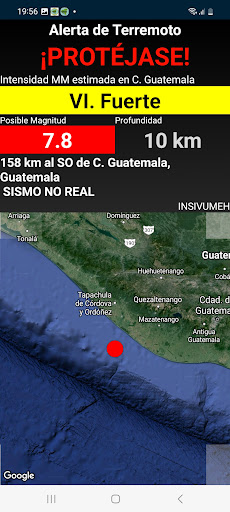
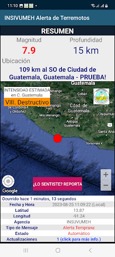
The application's core functionality centers around real-time earthquake detection through interconnected seismic instruments and algorithms. Notifications are triggered when seismic activity reaches potentially perceptible levels, with the system attempting to provide seconds to minutes of advance warning depending on the user's distance from the epicenter. The alert system incorporates magnitude estimation, approximate location data, and intensity predictions based on INSIVUMEH's monitoring network. All data processing occurs automatically without human intervention, which contributes to both its speed and potential vulnerability to false alerts or missed events.
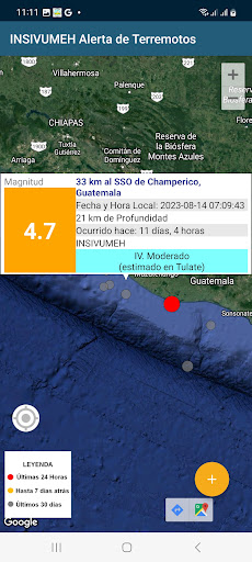
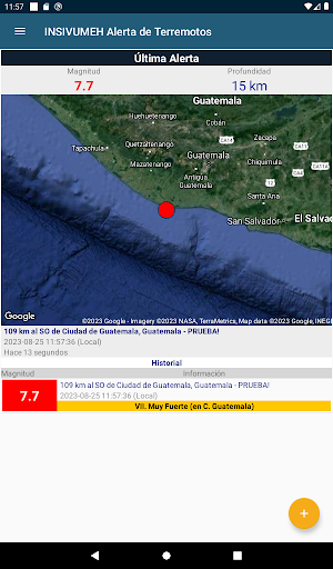
User experience is characterized by a utilitarian interface prioritizing functionality over aesthetics. The main screen displays recent seismic events with basic parameters including magnitude, depth, and location. Notification settings allow users to customize alert thresholds based on minimum magnitude and distance preferences. Real-world usage patterns indicate the application operates primarily in the background, with push notifications serving as the primary user interaction point during seismic events. The interface includes basic educational resources about earthquake safety procedures and preparedness measures.
No specific user reviews are available for detailed analysis at this time. The application's 4.1 rating suggests generally positive reception, though the absence of published reviews prevents examination of specific user experiences, common issues, or satisfaction patterns that typically inform comprehensive assessment.
The application's primary strength lies in its official connection to Guatemala's national seismic monitoring infrastructure, providing potentially more accurate local data than international alternatives. However, limitations include the acknowledged possibility of technical failures in the automated system, regional specificity that limits usefulness outside Guatemala, and dependence on network connectivity for alert delivery. Ideal use cases involve Guatemalan residents seeking supplementary earthquake information alongside official government channels and international monitoring services.
Key Features
- •Real-time earthquake notifications provide immediate alerts when seismic activity exceeds user-defined magnitude and distance thresholds
- •Early warning capability attempts to deliver seconds to minutes of advance notice depending on epicenter distance and detection speed
- •Automated monitoring system integrates multiple seismic instruments and algorithms for comprehensive coverage without human intervention
- •Customizable alert settings allow users to filter notifications based on minimum magnitude and maximum distance preferences
- •Official INSIVUMEH data connection ensures information comes directly from Guatemala's national seismic monitoring network
- •Educational resources include basic earthquake safety information and preparedness guidelines for immediate protective actions
Why Users Love It
Official seismic monitoring data
Potential early warning capability
Perfect for: Guatemalan residents seeking earthquake alerts and preparedness information
Screenshots


App Details
Developer
GEO INSIVUMEH
Platform
androidRating
★4.1
Last Updated
9/7/2025
Other Education Apps
Learn English, Spanish: Learna
Codeway Dijital
ANDROID 4.6
#1Duolingo: Language Lessons
Duolingo
ANDROID 4.5
#2ABCmouse 2: Kids Learning Game
Age of Learning, Inc.
ANDROID 4.5
#3Simply Draw: Learn to Draw
Simply Ltd
ANDROID 4.8
#4Epic: Kids' Books & Reading
Epic Kids Inc.
ANDROID 4.1
#5PBS KIDS Video
PBS KIDS
ANDROID 4.1
#6