GPS Map Camera & Navigation App Review: A Dual-Purpose Tool for Travelers
by RACCOON TECH
This app combines location tagging for photos with basic turn-by-turn navigation in a single interface. For anyone who wants to visually document their travels with precise coordinates overlaid on images, it provides a straightforward solution. The inclusion of offline maps makes it a practical choice for areas with unreliable data connections.
Detailed Review
GPS Map Camera & Navigation by RACCOON TECH enters a crowded marketplace with a specific proposition: merging photography with geographic data. Unlike standalone navigation or camera apps, it seeks to serve users who require proof of location or wish to create geographically cataloged visual diaries. Its position is that of a niche utility tool rather than a mainstream map replacement, focusing on simplicity and a specific feature set over advanced routing algorithms or social photo-sharing integrations.
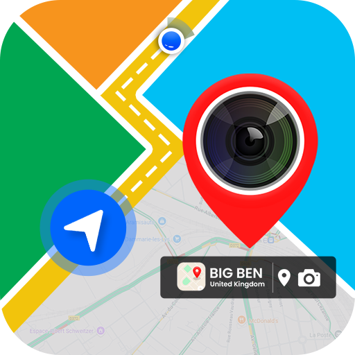
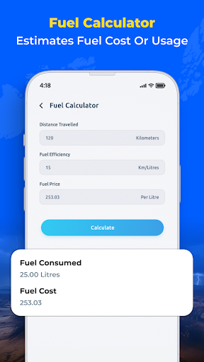
The core functionality revolves around two main pillars. The camera module allows users to capture photos that are automatically stamped with the current address, coordinates, date, time, and even altitude. These stamps can be customized with different fonts and layouts before saving or sharing. Concurrently, the navigation module offers point-to-point driving directions, searchable points of interest, and the crucial ability to download regional maps for offline use. This is particularly beneficial for hiking, road trips in remote areas, or international travel where avoiding roaming charges is a priority.
In practical use, the app presents a functional but somewhat utilitarian experience. The interface is clean, though some menu labels can feel vaguely translated. Starting a navigation route while simultaneously having the camera ready for geotagged photos works smoothly, which is the app's primary selling point. However, the navigation itself lacks the real-time traffic updates, lane guidance, and sophisticated rerouting found in dedicated apps like Google Maps or Waze. It performs reliably for basic A-to-B journeys, especially with pre-downloaded maps, but isn't intended for complex urban commuting.
As a relatively new app with no published reviews, gauging widespread user sentiment is challenging. However, examining feedback on similar apps in the category indicates that the primary user values are offline accessibility and the convenience of embedded location data in photos. Potential pain points for users often involve battery consumption from constant GPS use and accuracy discrepancies in the map data for less-developed regions. A balanced view suggests the app fills a clear need for a specific audience, even if it doesn't aim to compete with comprehensive navigation suites.
Overall, GPS Map Camera & Navigation is a competent specialist tool. Its strength lies in doing a few things quite well: geotagging photos with customizable data and providing reliable offline navigation. Its limitations are tied to its scope—it won't replace a user's primary mapping application for daily use. For travelers, field researchers, or outdoor enthusiasts who need to document locations visually without carrying multiple apps, it presents a valid and streamlined option.
Key Features
- •**Geotagged Camera:** Captures photos with automatically overlaid stamps showing address, GPS coordinates, date, and time, which can be customized before saving.
- •**Offline Map Navigation:** Allows users to download maps for entire regions or countries to access turn-by-step driving directions without an internet connection.
- •**Dual-View Interface:** Enables simultaneous use of the camera and a small map viewfinder, showing your current position and surrounding area as you take pictures.
- •**Location History Log:** Keeps a detailed log of visited places with timestamps, useful for creating travel itineraries or expense reports.
- •**Customizable Data Stamps:** Offers multiple templates and fonts for the location text overlay on photos, providing some control over the final image composition.
- •**Points of Interest Search:** Includes a searchable database of businesses and landmarks, though its depth may vary depending on the region and map data.
Why Users Love It
All-in-one photo geotagging and navigation
Essential offline functionality
Perfect for: Perfect for travelers, hikers, and field workers who need to document locations visually and navigate offline.
Screenshots


Ranking History
Track GPS Map Camera & Navigation's performance in Maps & Navigation over the last 30 days
Top 5
Top 10
Top 15
Below 15
Current Rank
#47
→
Best Rank
#17
All-time high
Average Rank
#28
30-day average
App Details
Developer
RACCOON TECH
Platform
androidRating
★3.8
Last Updated
12/16/2025