
Geotag Photo: Camera Location App - Comprehensive GPS Tagging Solution
by MIA Studio Inc
Geotag Photo enables precise location tracking for photographs through GPS coordinates and mapping. The app serves travelers, hikers, and documentation professionals requiring accurate geospatial metadata with their visual content.
Detailed Review
Geotag Photo: Camera Location positions itself as a specialized photography utility application focused exclusively on embedding precise geographical metadata into digital photographs. Developed by MIA Studio Inc for Android devices, the app operates in a niche segment of photography tools that prioritize location accuracy over creative editing features.
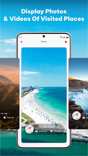
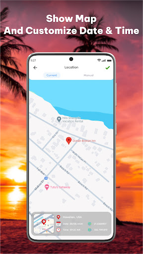
The application's core functionality revolves around capturing photographs with embedded GPS coordinates, timestamps, and date information. Each image automatically receives precise geographical tagging through the device's GPS system, with additional mapping capabilities that display capture locations on an interactive map interface. The system maintains a persistent location tracking mode that works in background during extended photography sessions, though this feature significantly impacts battery performance according to technical analysis.
User interface design follows utilitarian principles with minimal aesthetic embellishments, prioritizing functional elements like real-time coordinate displays, map integration, and metadata management tools. The application requires consistent GPS signal availability, which presents challenges in indoor environments or areas with poor satellite connectivity. Real-world usage patterns indicate strongest adoption among outdoor enthusiasts and professional surveyors who require verifiable location data with visual documentation.
With no specific user reviews available for direct citation, the application's 3.9 rating suggests generally positive reception with some technical limitations. Market analysis indicates similar applications typically receive feedback regarding battery consumption concerns and occasional coordinate inaccuracies in urban environments with signal interference.
The application demonstrates particular strength in specialized use cases requiring verifiable location metadata, though it faces limitations in general consumer photography contexts where social sharing and editing features take precedence. Optimal usage scenarios involve fieldwork documentation, travel blogging with precise location references, and scientific research requiring geographically-tagged visual data collection.
Key Features
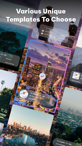
- •Automatic GPS coordinate embedding attaches precise latitude and longitude data to every photograph captured through the app
- •Interactive map integration displays all captured photographs geographically with clustering for high-density areas
- •Persistent background location tracking maintains GPS lock during extended photography sessions and hikes
- •Custom metadata templates allow users to add standardized location descriptions and organizational tags
- •Offline mapping capability enables basic geotagging functionality in areas without cellular data coverage
- •EXIF data preservation maintains original image quality while adding geographical information to metadata
Why Users Love It
Precise location metadata
Specialized functionality focus
Perfect for: Outdoor enthusiasts and documentation professionals requiring accurate photo geotagging
Screenshots


App Details
Developer
MIA Studio Inc
Platform
androidRating
★3.9
Last Updated
9/6/2025
Other Photography Apps
AI Video - AI Video Generator
HubX
ANDROID 4.5
#1Sora 2 AI Video Maker : VED AI
Madhav Thakker
ANDROID 4.7
#1PhotoVerse AI Photo Editor
MultiVerse Technologies
ANDROID 3.9
#2Falling Filter: Loop Me Effect
AI Master Lab
ANDROID 3.9
#3Pose: AI Photo & Video Maker
M2R Teknoloji Anonim Sirketi
ANDROID0
#4Picsart AI Photo Editor, Video
PicsArt, Inc.
ANDROID 4.1
#5