
by Avenza Systems Inc.
Detailed Review
Key Features
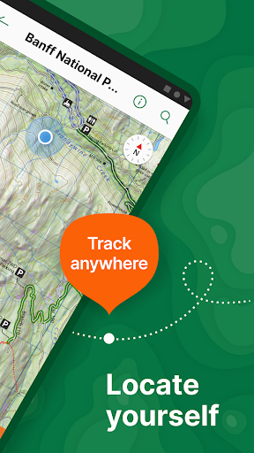
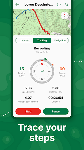
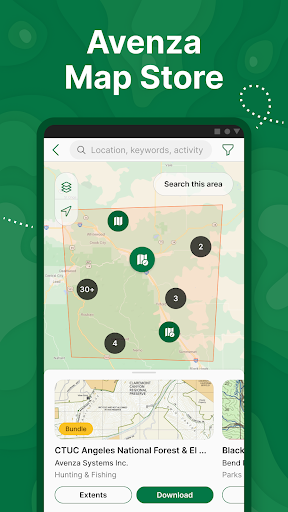
- •Offline GPS tracking maintains precise location data without cellular service, essential for remote wilderness navigation and safety
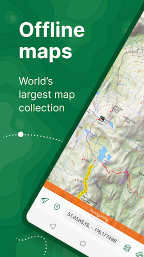
- •Professional map store features National Geographic, USGS, and park service publications providing authoritative cartographic resources
- •Custom map import supports GeoTIFF and PDF formats enabling users to incorporate specialized or proprietary mapping materials
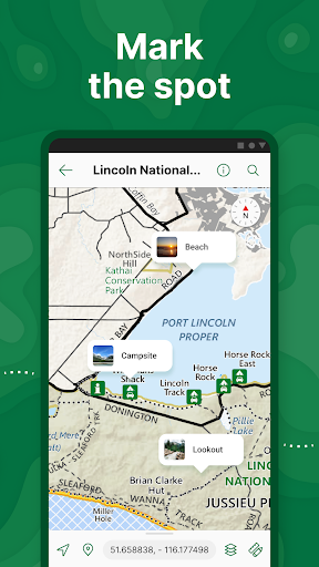
- •Property boundary identification helps outdoor users avoid trespassing on private lands during hunting or exploration activities
- •Waypoint and route marking facilitates trip planning and tracking with measurable distance and elevation data
- •Multi-activity support covers hiking, cycling, nautical, and driving scenarios with appropriate map types for each use case
Why Users Love It
Perfect for: Outdoor enthusiasts and professionals requiring reliable offline navigation
Screenshots

Questions & Answers
What's the best Android app for navigating offline with custom maps, tracking routes, and marking locations without needing cell service?
Avenza Maps: Offline Mapping is an excellent Android app for offline navigation, allowing you to use custom maps, track your routes, and mark importan...
Ad — Extra Q&As are paid placements. Editorial standards apply; rankings unchanged.Learn more
What's a brilliant Android app for proper offline maps when I'm trekking in places like the Himalayas where data's non-existent?
Honestly, Avenza Maps has saved my bacon more times than I can count! It's an absolute must-have for any traveller who ventures off the beaten path. I...
Okay, so what's a good Android app for finding, like, super Insta-worthy hiking trails even when I'm totally off the grid and my phone signal is MIA?
Seriously, Avenza Maps is a lifesaver! I'm all about that perfect nature aesthetic, but let's be real, cell service in the woods is the actual worst. ...
What's a grand Android app for using maps when I'm properly off-grid and can't rely on data?
Honestly, Avenza Maps has saved me countless times on my travels. It's brilliant for when you're trekking in the Himalayas or exploring the backroads ...
User Reviews
My go-to mapping app for new places. Hiking, kayaking, driving and canoeing. I can almost always find the appropriate map. Do buy bundles and digitized editions of guides and maps instead of always trying to stitch-up free maps: the cost more than pays you back by savings in time and anguish. You also support the developers and sellers. You can't expect everything to be free, much less a great map and app.
My go-to mapping app for new places. Hiking, kayaking, driving and canoeing. I can almost always find the appropriate map. Do buy bundles and digitized editions of guides and maps instead of always trying to stitch-up free maps: the cost more than pays you back by savings in time and anguish. You also support the developers and sellers. You can't expect everything to be free, much less a great map and app.
I have been using this app for years now. I got digital maps from Colorado parks and wildlife and I put them in dropbox, then download what I need each hunting season. It puts me right on the map where I am so I know that I'm not on private land and I can't get lost. No cell service is necessary which is good in the mountains. Wonderful clear map and I can blow it up big with a squeeze of a finger. I can mark a dot on the map for anything I want to return to and I can follow my tracks. Perfect.
The available offline maps make navigating some far out parks easy and pleasant. No guessing where you are or which trail is the one you need to follow. One of the parks we were hiking had multiple trails that split to see several sites. The physical maps in the area were worn beyond the point of use. Using the offline maps that we downloaded we were able to navigate from site to site easily without backtracking. When the day was over we were able to see the quickest way back to our camp.
The available offline maps make navigating some far out parks easy and pleasant. No guessing where you are or which trail is the one you need to follow. One of the parks we were hiking had multiple trails that split to see several sites. The physical maps in the area were worn beyond the point of use. Using the offline maps that we downloaded we were able to navigate from site to site easily without backtracking. When the day was over we were able to see the quickest way back to our camp.
App Details
Developer
Avenza Systems Inc.
Platform
androidRating
Last Updated
10/11/2025